Journal Article Summary
Summary: Introducing Teachers and University Students to GPS Technology
Title: “Introducing teachers and university students to GPS technology and its importance in remote sensing through GPS treasure hunts”
Name: Diane E. Main
Date: September 30, 2008
APA Reference:
Munro-Stasiuk, M.J. (2006). Introducing teachers and university students to GPS technology and
its importance in remote sensing through GPS treasure hunts. Journal of Geoscience
Education. 54(4), 471-5. Retrieved September 25, 2008 from Wilson Web.
Problem:
The author taught her geography students the fundamentals of Global Positioning Systems (GPS) technology in preparation for using GPS receivers in collecting data at specific locations on the planet’s surface. The author found that when they later needed to use the GPS units, students often could not remember how. Just knowing what made it work and what it measured did not equate to a working knowledge of using the device in a practical setting. The author continually provided “refresher” instruction in the field on how to use the devices. She hypothesized that by engaging the learners in a non-threatening activity using the units, there would be better retention of how to use the devices when they were needed for real-world situations in her classes.
Context:
The author used GPS “treasure hunt” activities with 297 university students and K-12 teachers in fifteen classes from 2002 to 2005. This took place in the Cleveland, Ohio area, and involved five teacher professional development courses, five geospatial courses, and five introductory or intermediate level geography courses. The participants included 101 teachers, 21 introductory students, 47 intermediate students, and 128 advanced students.
The participants learned how to use GPS receivers and went on “treasure hunts” to find predetermined locations. K-12 teachers used latitude and longitude measurements, and geography students used Universal Transverse Mercator (UTM). This aligns with the standards they use in their different work.
Findings:
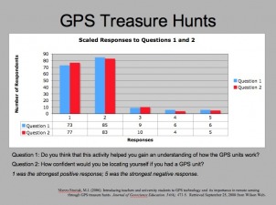
The author tracked how well the groups found the targets. Of 98 groups, 87 found all the sites or objects, and the remaining eleven groups found all but one or two sites. The author also used a simple questionnaire with the participants during the first three years. She found that while only 34% of the participants had used GPS units before, 89% felt comfortable using the units afterward. 88% believed the activity helped them comprehend GPS, and 89% felt confident determining their locations with GPS units. Negative responses generally came from people who had been in groups where one user dominated the GPS receiver, so the author attempted to avoid this happening later by having more units available.
Recommendations:
After using GPS receivers with my students, I agree that such hands-on activities truly do make the learning more permanent. Similar “treasure hunts” can be applied to a wide range of content (not just geography) with similar success.
GPS activities enhance learning for many reasons:
1. Motivation: The activities are fun for learners of all ages, so there will be increased attention to instruction.
2. Multiple modalities: Kinesthetic learners are not restrained, as they might be in traditional classrooms. Auditory and visual learners also benefit from the multi-sensory activities.
3. Immediate feedback: Learners know right away if they have achieved the goal.
4. Opportunities for correction: Learners can go back and try another option if their first attempts are unsuccessful.
5. 21st Century Skills: Learners working in groups learn how to communicate effectively, share resources, and rely on others while also leading at times.
The image on this page is a screen shot of a slide used when presenting this summary to an online class. It displays the results mentioned in the "Findings" section of this summary.
|
Copyright ©2008 Diane Main. All rights reserved.
Created for the Educational Technology Department San Diego State University |
 Click the image to learn more about the program. |
